Rain to Snow Calculator
Find out how much snow a forecast’s rain total would make, or how much water is locked up in the snow on the ground. Enter an amount in inches or millimetres, pick the temperature or snow type, and the calculator applies the right snow-to-liquid ratio instead of the one-size-fits-all 10:1 rule. You also get the likely range, the snow’s weight on a roof and a 48-hour rain-or-snow forecast for any city or ZIP code.
Convert Rain to Snow
Enter an amount and the temperature to see how much snow the same water makes, or switch modes to go from snow back to rain.
Real storms at this temperature usually make 5–10 in of snow from this much water.
Show the formula with your numbers
Snow = Rain × Ratio = 1 in × 10 = 10 in
Rain or Snow? 48-Hour Forecast for Your Area
See hour by hour whether the forecast is rain, snow or a mix, and how much snow the expected water would make.
- Snow
- Mix / near freezing
- Rain
Rain to Snow Ratio Chart
| Air temperature | NWS table ratio | Snow from 1 in of rain | Typical in real storms | Snow type |
|---|---|---|---|---|
| 28 to 34°F (-2 to 1°C) | 10 : 1 | 10 in (25 cm) | 5–10 in | Wet, heavy snow |
| 20 to 27°F (-7 to -3°C) | 15 : 1 | 15 in (38 cm) | 10–15 in | Average snow |
| 15 to 19°F (-9 to -7°C) | 20 : 1 | 20 in (51 cm) | 12–18 in | Light, drier snow |
| 10 to 14°F (-12 to -10°C) | 30 : 1 | 30 in (76 cm) | 15–20 in | Dry, fluffy snow |
| 0 to 9°F (-18 to -13°C) | 40 : 1 | 40 in (102 cm) | 15–30 in | Very dry powder |
| -20 to -1°F (-29 to -18°C) | 50 : 1 | 50 in (127 cm) | 15–30 in | Very dry powder |
| -40 to -21°F (-40 to -29°C) | 100 : 1 | 100 in (254 cm) | 15–30 in | Very dry powder |
| Above 34°F (1°C) | – | Usually falls as rain | – | Rain or wet snow that melts |
| Rain (liquid) | Wet 7:1 | Average 10:1 | US average 13:1 | Dry 17:1 | Powder 25:1 |
|---|---|---|---|---|---|
| 0.1 in (2.5 mm) | 0.7 in | 1 in | 1.3 in | 1.7 in | 2.5 in |
| 0.25 in (6.4 mm) | 1.8 in | 2.5 in | 3.3 in | 4.3 in | 6.3 in |
| 0.5 in (12.7 mm) | 3.5 in | 5 in | 6.5 in | 8.5 in | 12.5 in |
| 0.75 in (19 mm) | 5.3 in | 7.5 in | 9.8 in | 12.8 in | 18.8 in |
| 1 in (25.4 mm) | 7 in | 10 in | 13 in | 17 in | 25 in |
| 1.5 in (38.1 mm) | 10.5 in | 15 in | 19.5 in | 25.5 in | 37.5 in |
| 2 in (50.8 mm) | 14 in | 20 in | 26 in | 34 in | 50 in |
The NWS table is the snowfall-to-meltwater conversion table used by US weather observers. Its very high ratios (40:1 to 100:1) are rare in real storms, so the calculator also shows the range most storms actually produce. Ratios depend on the temperature through the whole cloud, not just at the ground, so treat every result as an estimate.
What Is the Rain to Snow Ratio?
The rain to snow ratio, also called the snow-to-liquid ratio or SLR, compares the depth of fresh snow with the depth of water it melts down to. A 10:1 ratio means 10 inches of snow holds 1 inch of water. A 20:1 ratio means the same inch of water arrives as 20 inches of light, fluffy snow.
The ratio exists because a snowflake is mostly air. How much air depends on the flake’s shape, how wet it is, how much it is broken up by wind on the way down and how quickly it settles once it lands. Warm, wet snow packs tightly and gives a low ratio. Cold, dry snow made of branching crystals traps far more air and gives a high ratio.

Is the 10:1 rule right?
The 10:1 rule goes back to the US Weather Bureau in the 1870s, and even then it was described as a rough approximation. It works best for snow that falls with temperatures around 30°F.
A 30-year study of snowfall across the United States found that the average ratio is closer to 13:1, and that real storms range from about 2:1 for heavy, wet snow to around 50:1 for very dry powder. That is why the calculator offers seven methods instead of one fixed number:
| Method | Ratio used | Best for |
|---|---|---|
| By temperature | 10:1 to 100:1 | When you know the air temperature during the snow |
| Wet, heavy snow | 7:1 | Snow near 32°F, coastal storms, snow mixed with rain |
| Classic rule | 10:1 | Quick estimates and comparing with older forecasts |
| US average | 13:1 | A typical inland storm when you don’t know the temperature |
| Dry snow | 17:1 | Cold storms in the teens |
| Powder | 25:1 | Very cold, calm, high-elevation or lake-effect snow |
| Custom | Any number | When your local forecaster quotes a ratio |
Rain to Snow Formula
The conversion is a single multiplication:
Snow depth = liquid amount × snow ratio
And the reverse:
Liquid amount = snow depth ÷ snow ratio
The calculator shows this working under every result so you can check it yourself.
Worked examples
- 0.5 inch of rain at 30°F: 0.5 × 10 = 5 inches of snow. Real-world range at that temperature: about 2.5 to 5 inches.
- 0.5 inch of rain at 22°F: 0.5 × 15 = 7.5 inches of snow.
- 0.25 inch of rain at 12°F: 0.25 × 30 = 7.5 inches by the official table, though 4 to 5 inches is more common in practice.
- 10 mm of rain at 10:1: 10 × 10 = 100 mm, or 10 cm of snow. In metric, a handy shortcut is that 1 mm of water makes roughly 1 cm of snow at 10:1.
- Find your ratio: you measured 8 inches of new snow and it melted to 0.6 inch of water. 8 ÷ 0.6 = about 13:1, right on the US average.
How Temperature Changes the Snow Ratio
Temperature is the best single clue to the ratio. The “By temperature” method uses the conversion table weather observers use in the United States, and shows a typical real-world range beside it, because the official table tends to run high in very cold air.
| Air temperature | Official ratio | Typical real-world ratio | What the snow is like |
|---|---|---|---|
| 28 to 34°F (−2 to 1°C) | 10:1 | 5:1 to 10:1 | Wet, heavy, good for snowmen, hard to shovel |
| 20 to 27°F (−7 to −3°C) | 15:1 | 10:1 to 15:1 | Average snow for most storms |
| 15 to 19°F (−9 to −7°C) | 20:1 | 12:1 to 18:1 | Dry and light |
| 10 to 14°F (−12 to −10°C) | 30:1 | 15:1 to 20:1 | Powder that blows around easily |
| 0 to 9°F (−18 to −13°C) | 40:1 | 15:1 to 30:1 | Very dry, small crystals can actually pack down |
| Below 0°F (below −18°C) | 50:1 to 100:1 | 15:1 to 30:1 | Tiny crystals, little total snow |

Two things surprise most people.
First, the coldest air does not always give the deepest snow: in extreme cold the crystals stay small and needle-like and pack closer together than the big branching flakes that form near 5°F to 10°F inside the cloud.
Second, the temperature that matters most is the one inside the cloud where the flakes grow, not just the one on your porch. That is why the calculator gives a range, not a single promise.
Above 34°F the calculator shows a warning: snow can still fall at 35°F to 38°F if the air is dry, but it melts as it lands and very little piles up.
How Much Snow Is 1 Inch of Rain?
One inch of rain makes about 10 inches of snow by the classic rule, but the honest answer is anywhere from about 5 to 20 inches for most storms, and occasionally more.
| Rain (liquid) | Wet snow (7:1) | Classic (10:1) | US average (13:1) | Dry snow (17:1) | Powder (25:1) |
|---|---|---|---|---|---|
| 0.1 in | 0.7 in | 1 in | 1.3 in | 1.7 in | 2.5 in |
| 0.25 in | 1.8 in | 2.5 in | 3.3 in | 4.3 in | 6.3 in |
| 0.5 in | 3.5 in | 5 in | 6.5 in | 8.5 in | 12.5 in |
| 1 in | 7 in | 10 in | 13 in | 17 in | 25 in |
| 2 in | 14 in | 20 in | 26 in | 34 in | 50 in |
So when a winter forecast says “about an inch of liquid,” it is talking about a big storm: likely 8 to 15 inches of snow if the whole thing falls as snow.
Snow to Rain: How Much Water Is in Snow?
Switch the calculator to Snow → Rain to turn a snow depth into its water equivalent, also called the liquid equivalent or snow water equivalent (SWE). Divide the snow depth by the ratio:
- 12 inches of wet snow at 7:1 holds about 1.7 inches of water.
- 12 inches of average snow at 13:1 holds about 0.9 inch of water.
- 12 inches of powder at 25:1 holds only about 0.5 inch of water.
This matters for spring flooding, for gardeners and farmers watching soil moisture, and for anyone comparing a snowy month with a rainy one. If you have a rain gauge, the Find my ratio mode lets you work out the real ratio of your last storm: melt a core of new snow, enter the snow depth and the water you measured, and the calculator tells you the ratio and how it compares with average.
Rain to snow ratio by region (approximate)
Averages vary a lot by place. Use these as a starting point, not a rule:
| Region | Typical ratio | Why |
|---|---|---|
| Pacific Northwest and California mountains | 7:1 to 10:1 | Mild ocean air, wet “Sierra cement” |
| Mid-Atlantic and Southeast | 8:1 to 11:1 | Storms often near freezing, mixed with sleet |
| Northeast coast | 10:1 to 12:1 | Nor’easters with temperatures in the upper 20s |
| Great Lakes (lake-effect) | 15:1 to 25:1 | Cold air, tall clouds, big branching flakes |
| Northern Plains and Upper Midwest | 15:1 to 20:1 | Cold, dry air masses |
| Interior Rockies | 15:1 to 20:1 or more | Dry air and high elevation, famous for powder |
Check how often snow falls where you live on our city pages, for example Buffalo, Minneapolis and Denver.
Will It Rain or Snow?
Most winter precipitation starts as snow high in the cloud. Whether it reaches you as snow depends on the air it falls through on the way down:
- Snow: the air stays at or below freezing all the way to the ground, or is only slightly above freezing near the surface.
- Rain: the flakes fall through a deep layer of air above freezing and melt completely.
- Sleet: the flakes melt in a warm layer, then refreeze into ice pellets in a deep cold layer near the ground.
- Freezing rain: the flakes melt in a warm layer, and the cold layer near the ground is too shallow to refreeze them, so the drops freeze on contact with roads, trees and power lines.
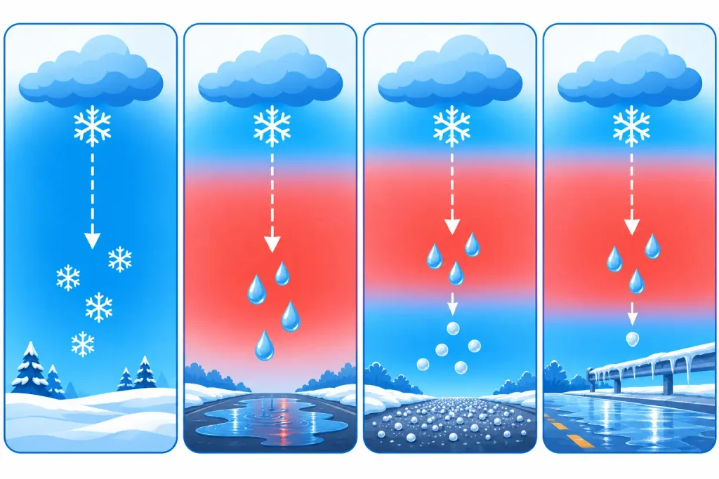
That is why it can rain at 33°F on one storm and snow at 37°F on another. Dry air helps too: when snow falls into dry air, some of it evaporates and cools the air around it, which can turn rain to snow in the middle of a storm.
The 48-hour forecast in the tool shows the expected precipitation hour by hour, marks each hour as rain, snow or a mix based on its temperature, and adds up the totals, so you can see when a storm is likely to switch over.
Sleet and freezing rain don’t follow snow ratios
Sleet is roughly 2:1 to 3:1, so an inch of liquid makes only 2 to 3 inches of ice pellets. Freezing rain doesn’t pile up at all, it coats. A quarter inch of ice on trees and lines can do more damage than a foot of snow. If the forecast mentions sleet or freezing rain, use the forecast’s ice amount rather than converting it to snow. Ice is also one of the biggest reasons schools close, which the snow day calculator takes into account.
What about the Kuchera method?
Many weather maps show two snowfall totals: one at 10:1 and one labelled Kuchera. The Kuchera method estimates the ratio from the warmest temperature in the lower atmosphere, so it gives higher totals in cold storms and lower totals in marginal ones. It is usually closer to reality than a flat 10:1 but still tends to overdo very cold, windy storms. If you have a Kuchera ratio from a forecast, enter it in the calculator’s Custom box.
Snow Weight and Density
The ratio also tells you how heavy the snow is, which is why the result shows density and roof load as well as depth.
- Density: a 10:1 snow is about 10% water by volume, a 7:1 snow is about 14%, a 25:1 powder is only 4%.
- Roof load: every inch of water in the snow weighs about 5.2 lb per square foot (1 mm of water = 1 kg per square metre). So a foot of wet 7:1 snow weighs roughly 9 lb/ft², while a foot of powder weighs about 2.5 lb/ft².
- Shovelling: a 10 × 30 ft driveway covered in 6 inches of heavy, wet snow holds roughly 1,300 lb of snow. The same depth of powder is closer to 375 lb.
Wind also affects how snow accumulates. Strong winds can break snowflakes into smaller pieces that pack more tightly, resulting in a lower snow-to-liquid ratio than temperatures alone might suggest. They can also create deep snowdrifts in some areas while leaving nearby surfaces relatively bare.
If strong winds are expected, use our Wind Chill Calculator to check how cold it will feel outside. The combination of freezing temperatures and strong winds can increase frostbite risk, especially for students waiting at bus stops or walking to school.
Using the 48-Hour Forecast
You don’t need to look up a forecast elsewhere. Search a city or US ZIP code, or tap My location, and the tool:
- Pulls the next 48 hours of temperature and precipitation from Open-Meteo.
- Shows a bar for each hour, coloured for rain, snow or a mix.
- Totals the expected liquid and snow, and how many hours of each.
- Loads the forecast into the calculator above, using the temperature of the snowiest hour, so the conversion matches your real weather.
Every result has a Copy link button. The link keeps your amount, units, method and location, so you can send it to family or bookmark it for the next storm.
What Snow Amounts Mean for School
The same inch of snow means very different things in different places. A school district in Buffalo plans for a lot of snow, a district in Atlanta may close for an inch. As a rough guide:
| New snow by morning | What usually happens |
|---|---|
| Under 1 inch | School open in most places, delays possible in the South |
| 1 to 3 inches | Delays common, closures likely where snow is rare |
| 4 to 6 inches | Closures common outside the snowiest regions |
| 6 inches or more | Closures likely almost everywhere, especially if it falls overnight |
| Any freezing rain | Delays and closures likely, even with no snow |
Timing matters as much as the total: snow between about 4 AM and 9 AM, when buses run, does the most damage to a school day. When your result is 1 inch of snow or more, the tool shows a link to check the full picture with our snow day calculator, which weighs your city’s usual snowfall, the morning timing, ice, wind chill and active weather alerts. It also gives a separate chance of a 2-hour delay. You can read how our predictions work or browse snow day odds by city.
Frequently Asked Questions
How do you convert rain to snow?
Multiply the amount of rain (liquid) by the snow ratio. At the classic 10:1 ratio, 0.4 inch of rain becomes 4 inches of snow. In colder air the ratio rises, so the same rain can make 6 to 8 inches of snow.
How many inches of snow equal 1 inch of rain?
About 10 inches by the traditional rule, and about 13 inches on average across the United States. Wet snow near freezing can be as little as 5 to 7 inches, very cold, dry snow can reach 20 inches or more.
What is the snow ratio at 32°F?
Around 10:1 or lower. Snow that falls right at freezing is wet and dense, and 5:1 to 8:1 is common, especially if it is mixed with rain.
At what temperature does rain turn to snow?
Usually when the surface temperature drops to about 32°F to 34°F, but what really decides it is the temperature of the whole column of air the flakes fall through. With dry air, snow can reach the ground at 35°F to 38°F, with a warm layer above you, it can rain below freezing (freezing rain).
How much snow is 10 mm of rain?
About 10 cm of snow at 10:1, about 13 cm at the 13:1 average and up to 20 cm or more in very cold air. At 10:1, each millimetre of water makes about a centimetre of snow.
How much rain is 1 foot of snow?
At 10:1, 12 inches of snow melts to 1.2 inches of water. Wet snow could be 1.5 to 2 inches of water, powder could be half an inch or less.
Why do snowfall forecasts change so much?
A small change in the ratio makes a big change in the total. Half an inch of liquid is 5 inches at 10:1 but 8.5 inches at 17:1. Forecasters are often confident about the liquid amount and much less sure about the ratio and the exact temperature.
Does wind change the snow ratio?
Yes. Wind breaks flakes into small pieces that pack together, lowering the ratio, and it moves snow into drifts, so measured depth varies a lot from spot to spot.
Is the calculator accurate for sleet or freezing rain?
No. Sleet packs at roughly 2:1 to 3:1 and freezing rain forms a glaze, not a snow layer. Use the forecast’s ice amount for those.
Will 3 inches of snow close school?
It depends on where you live, how early the snow falls and whether there is ice. Three inches closes schools in much of the South but rarely in the Great Lakes. Check your chance of a snow day for a prediction for your city.