Wind Chill Calculator
Enter the air temperature and wind speed to see the wind chill, how fast exposed skin can get frostbite, and what to wear. It works in °F or °C with wind in mph, km/h, m/s or knots. Or search your city or ZIP code for the live wind chill and a 24-hour forecast, including the coldest point of the morning school run.
Calculate the Wind Chill
Enter the air temperature and wind speed to get the wind chill (feels-like temperature) and how fast frostbite can set in.
🏍️ Riding a motorcycle or bike? Add your speed
On a moving bike, the air hitting you is your speed plus the wind. Wind chill is calculated for bare skin, so a full-face helmet and gloves protect most of you, but any gap is exposed to this wind chill.
At 10°F with a 20 mph wind, it feels like -9°F.
What to wear: layers with a windproof outer shell, plus a hat, mittens and a scarf or neck warmer.
Hourly wind chill for the next 24 hours: taller bars are colder, and colours match the frostbite risk in the chart below. Hover over or tap a bar for its value.
Show the formula with your numbers
Wind Chill Chart
Find the air temperature along the top and the wind speed down the side. Tap any value to load it into the calculator.
| Wind ↓ / Air → | 40°F | 35°F | 30°F | 25°F | 20°F | 15°F | 10°F | 5°F | 0°F | -5°F | -10°F | -15°F | -20°F | -25°F | -30°F | -35°F | -40°F | -45°F |
|---|---|---|---|---|---|---|---|---|---|---|---|---|---|---|---|---|---|---|
| 5 mph | 36 | 31 | 25 | 19 | 13 | 7 | 1 | -5 | -11 | -16 | -22 | -28 | -34 | -40 | -46 | -52 | -57 | -63 |
| 10 mph | 34 | 27 | 21 | 15 | 9 | 3 | -4 | -10 | -16 | -22 | -28 | -35 | -41 | -47 | -53 | -59 | -66 | -72 |
| 15 mph | 32 | 25 | 19 | 13 | 6 | -0 | -7 | -13 | -19 | -26 | -32 | -39 | -45 | -51 | -58 | -64 | -71 | -77 |
| 20 mph | 30 | 24 | 17 | 11 | 4 | -2 | -9 | -15 | -22 | -29 | -35 | -42 | -48 | -55 | -61 | -68 | -74 | -81 |
| 25 mph | 29 | 23 | 16 | 9 | 3 | -4 | -11 | -17 | -24 | -31 | -37 | -44 | -51 | -58 | -64 | -71 | -78 | -84 |
| 30 mph | 28 | 22 | 15 | 8 | 1 | -5 | -12 | -19 | -26 | -33 | -39 | -46 | -53 | -60 | -67 | -73 | -80 | -87 |
| 35 mph | 28 | 21 | 14 | 7 | 0 | -7 | -14 | -21 | -27 | -34 | -41 | -48 | -55 | -62 | -69 | -76 | -82 | -89 |
| 40 mph | 27 | 20 | 13 | 6 | -1 | -8 | -15 | -22 | -29 | -36 | -43 | -50 | -57 | -64 | -71 | -78 | -84 | -91 |
| 45 mph | 26 | 19 | 12 | 5 | -2 | -9 | -16 | -23 | -30 | -37 | -44 | -51 | -58 | -65 | -72 | -79 | -86 | -93 |
| 50 mph | 26 | 19 | 12 | 4 | -3 | -10 | -17 | -24 | -31 | -38 | -45 | -52 | -60 | -67 | -74 | -81 | -88 | -95 |
| 55 mph | 25 | 18 | 11 | 4 | -3 | -11 | -18 | -25 | -32 | -39 | -46 | -54 | -61 | -68 | -75 | -82 | -89 | -97 |
| 60 mph | 25 | 17 | 10 | 3 | -4 | -11 | -19 | -26 | -33 | -40 | -48 | -55 | -62 | -69 | -76 | -84 | -91 | -98 |
| Wind ↓ / Air → | 5°C | 0°C | -5°C | -10°C | -15°C | -20°C | -25°C | -30°C | -35°C | -40°C | -45°C | -50°C |
|---|---|---|---|---|---|---|---|---|---|---|---|---|
| 5 km/h | 4 | -2 | -7 | -13 | -19 | -24 | -30 | -36 | -41 | -47 | -53 | -58 |
| 10 km/h | 3 | -3 | -9 | -15 | -21 | -27 | -33 | -39 | -45 | -51 | -57 | -63 |
| 15 km/h | 2 | -4 | -11 | -17 | -23 | -29 | -35 | -41 | -48 | -54 | -60 | -66 |
| 20 km/h | 1 | -5 | -12 | -18 | -24 | -30 | -37 | -43 | -49 | -56 | -62 | -68 |
| 25 km/h | 1 | -6 | -12 | -19 | -25 | -32 | -38 | -44 | -51 | -57 | -64 | -70 |
| 30 km/h | 0 | -6 | -13 | -20 | -26 | -33 | -39 | -46 | -52 | -59 | -65 | -72 |
| 35 km/h | -0 | -7 | -14 | -20 | -27 | -33 | -40 | -47 | -53 | -60 | -66 | -73 |
| 40 km/h | -1 | -7 | -14 | -21 | -27 | -34 | -41 | -48 | -54 | -61 | -68 | -74 |
| 45 km/h | -1 | -8 | -15 | -21 | -28 | -35 | -42 | -48 | -55 | -62 | -69 | -75 |
| 50 km/h | -1 | -8 | -15 | -22 | -29 | -35 | -42 | -49 | -56 | -63 | -69 | -76 |
| 60 km/h | -2 | -9 | -16 | -23 | -30 | -36 | -43 | -50 | -57 | -64 | -71 | -78 |
| 70 km/h | -2 | -9 | -16 | -23 | -30 | -37 | -44 | -51 | -58 | -65 | -72 | -80 |
| 80 km/h | -3 | -10 | -17 | -24 | -31 | -38 | -45 | -52 | -60 | -67 | -74 | -81 |
- Low risk
- Moderate: cold injury with long exposure
- High: frostbite in 10–30 min
- Very high: 5–10 min
- Severe: 2–5 min
- Extreme: under 2 min
Risk levels follow Environment and Climate Change Canada's wind chill index (bands set on °C values). Values use the 2001 NWS / Environment Canada formula. Wind speed is measured 10 m (33 ft) above the ground, as in weather reports.
What Is Wind Chill?
Wind chill is how cold it feels on exposed skin when wind and cold air combine. It is given as a temperature: the still-air temperature that would draw heat from your skin at the same rate. At 0°F with a 15 mph wind, your face loses heat as fast as it would at −19°F on a calm day.
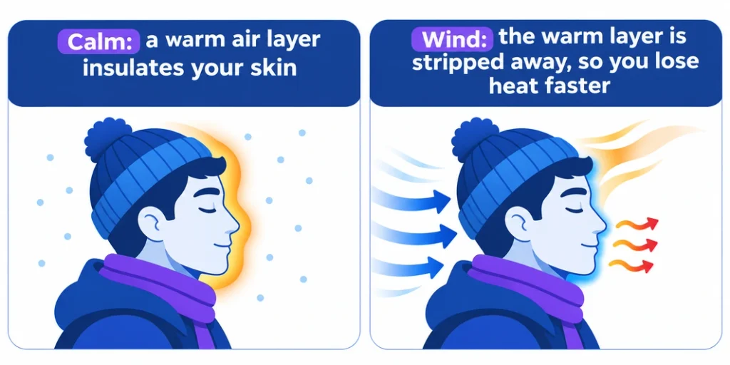
Your body keeps a thin layer of warm air right against your skin. In still air that layer stays put and insulates you. Wind strips it away, and your body has to warm a fresh layer of cold air again and again. This process is called convection, and it is why a windy day feels much colder than a calm one at the same temperature. The thermometer doesn’t change; only the rate of heat loss does.
Is wind chill the same as “feels like”?
In cold weather, yes. “Feels like” is the label weather apps put on whichever index fits the conditions:
- Wind chill: at 50°F (10°C) or colder with wind. It uses only temperature and wind.
- Heat index: in hot weather. It uses temperature and humidity.
- Humidex: Canada’s version of the heat index.
So if your app shows a “feels like” number on a 75°F day, that’s the heat index, not wind chill.
Wind Chill Formula
The United States and Canada use the same wind chill formula, introduced on November 1, 2001 by the National Weather Service (NWS) and Environment Canada. There are two versions of it, one for each unit system.
Fahrenheit, wind in mph (NWS):
WC = 35.74 + 0.6215T - 35.75V^{0.16} + 0.4275TV^{0.16}Celsius, wind in km/h (Environment Canada):
WC = 13.12 + 0.6215T - 11.37V^{0.16} + 0.3965TV^{0.16}T is the air temperature and V is the wind speed, measured 10 m (33 ft) above the ground as in weather reports. The formula adjusts it down to face height.
Worked examples
- 10°F with a 20 mph wind: 20^0.16 = 1.615, so WC = 35.74 + 6.22 − 57.74 + 6.90 = −8.9°F, which rounds to −9°F.
- −10°C with a 20 km/h wind: 20^0.16 = 1.615, so WC = 13.12 − 6.22 − 18.36 − 6.40 = −17.9°C, which rounds to −18°C.
You don’t need to do this by hand: open “Show the formula with your numbers” under any result and the calculator walks through it for you.
When the formula applies
Wind chill is only defined at 50°F (10°C) or colder with wind above 3 mph (4.8 km/h). Above 50°F, wind doesn’t make it dangerously cold, so the feels-like temperature is just the air temperature. In calm air the formula would give a number warmer than the air, which makes no sense. Our calculator tells you when you’re outside that range instead of showing a misleading number.
Old vs. new wind chill formula
Before 2001, the US and Canada used the Siple-Passel index from 1945. It was based on how fast water froze in a plastic cylinder in Antarctica, not on human skin, and it made conditions seem much colder than they are. The 2001 formula came from tests with volunteers walking into a cold wind tunnel with sensors on their faces, so it models heat loss from a human face and assumes no sunshine.
For the same 0°F and 15 mph, the old formula gives −31°F; the new one gives −19°F. The calculator’s formula panel shows both, so you can compare old charts or records.
Heat loss in watts per square meter
The calculator also shows the rate of heat loss from exposed skin in W/m², the same figure the National Weather Service’s own calculator gives. It comes from the original 1945 index, with wind in m/s and temperature in °C:
H = (12.1452 + 11.6222\sqrt{v} - 1.16222v)(33 - T)The higher the number, the faster bare skin loses heat.
How to Read the Wind Chill Chart
Find the air temperature across the top of the chart and the wind speed down the left side. Where they meet is the wind chill. The colour shows how quickly exposed skin can freeze. Tap any value in the chart above to load it into the calculator, or switch between the °F/mph and °C/km/h versions.
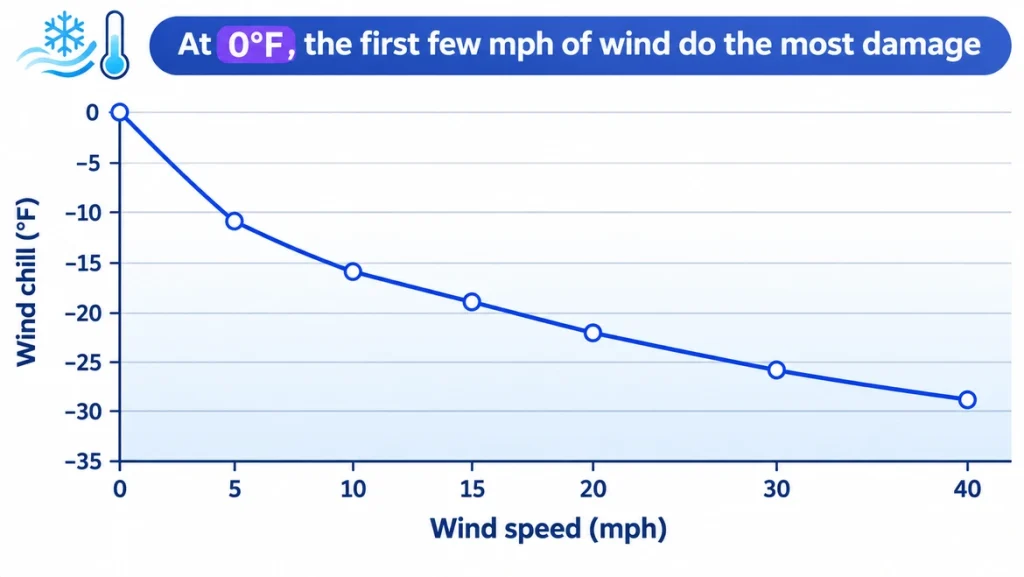
Read down any column and you’ll notice that the first few miles per hour of wind do the most damage. At 0°F, a 5 mph breeze already drops the wind chill to −11°F. Going from 5 to 15 mph takes it to −19°F, but going from 30 to 40 mph only moves it from −26°F to −29°F. That’s why a light breeze on a cold morning matters more than most people expect.
Frostbite Risk by Wind Chill
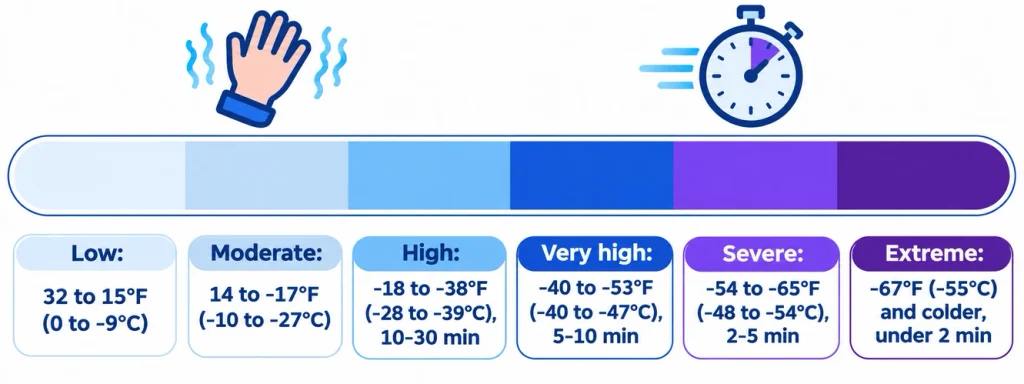
The main reason to check the wind chill is to know how long bare skin can safely be outside. The calculator uses Environment and Climate Change Canada’s risk levels, which are set on the °C value:
| Wind chill | Risk | Exposed skin can freeze in |
|---|---|---|
| 0 to −9°C (32 to 15°F) | Low | Unlikely; dress warmly |
| −10 to −27°C (14 to −17°F) | Moderate | Not quickly, but frostnip and hypothermia are possible with long exposure |
| −28 to −39°C (−18 to −38°F) | High | 10 to 30 minutes |
| −40 to −47°C (−40 to −53°F) | Very high | 5 to 10 minutes |
| −48 to −54°C (−54 to −65°F) | Severe | 2 to 5 minutes |
| −55°C (−67°F) and colder | Extreme | Under 2 minutes |
The US National Weather Service chart marks the same idea with three bands: frostbite in 30, 10 and 5 minutes or less. Both describe a healthy adult with dry, bare skin. Wet skin, tight boots, touching cold metal, tiredness, alcohol and smoking all make frostbite happen faster, so treat these times as the best case.
What to Wear at Each Wind Chill
Every result comes with advice for that risk level. In short:
- Low risk (above about 15°F / −10°C): a warm coat, hat and gloves.
- Moderate (down to about −17°F / −27°C): dress in layers: a thin base layer that wicks sweat, a warm middle layer like fleece or wool, and a windproof outer shell. Add a hat, mittens and a scarf or neck warmer.
- High (−18 to −38°F / −28 to −39°C): cover all exposed skin, especially your face, ears and hands. Keep time outside short and check each other for white or numb patches.
- Very high and colder: stay out only for a few minutes, with a full face cover, insulated mittens and boots, and warm up indoors often. In the extreme range, stay inside if you can.
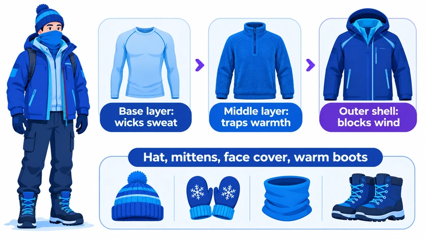
Mittens keep hands warmer than gloves, and staying dry matters as much as staying covered: damp clothing pulls heat away far faster than dry.
Signs of Frostbite and Hypothermia
A wind chill number tells you how fast heat is leaving your skin, not what is happening to a particular person. These are the warning signs to watch for, based on guidance from the US Centers for Disease Control and Prevention (CDC).
Frostbite
Frostbite is skin and the tissue under it freezing. It most often hits the nose, ears, cheeks, chin, fingers and toes. Redness or pain in any skin area can be the first sign. Then watch for:
- A white or grayish-yellow patch of skin
- Skin that feels unusually firm or waxy
- Numbness
Because the skin goes numb, people often don’t notice frostbite until someone else points it out, so check each other’s faces in severe cold. If you suspect frostbite, get to a warm place and seek medical care. Don’t rub the area or rub snow on it, and avoid walking on frostbitten feet unless you have to.
Hypothermia
Hypothermia means the body’s core temperature has dropped below 95°F (35°C). It is a medical emergency. In adults, the warning signs are:
- Shivering and exhaustion
- Confusion and memory loss
- Fumbling hands
- Slurred speech
- Drowsiness
Babies may have bright red, cold skin and very low energy. If someone shows these signs, get them into a warm room, remove any wet clothing, warm them under dry blankets, and get medical help right away.
Hypothermia doesn’t need freezing weather. Being wet from rain, sweat or cold water can cause it even when the air is above 40°F, a temperature where the wind chill formula doesn’t apply at all.
[This section is general safety information. Keep the CDC link in the sources, and don’t add dosing or treatment steps beyond the CDC’s.]
Motorcycle and Bicycle Wind Chill
On a moving bike, the air hitting you is your own speed plus any headwind. So a rider feels a far stronger “wind” than the weather report shows. Open “Riding a motorcycle or bike?” in the calculator, enter your speed, and choose headwind, crosswind or tailwind.
| Situation | Air temperature | Effective wind | Wind chill |
|---|---|---|---|
| Parked, light breeze | 20°F | 10 mph | 9°F |
| Cycling at 15 mph into a 10 mph headwind | 20°F | 25 mph | 3°F |
| Motorcycle on the highway at 60 mph | 40°F | 60 mph | 25°F |
| Motorcycle at 60 mph | 20°F | 60 mph | −4°F |
| Cycling at 25 km/h into a 15 km/h headwind | −5°C | 40 km/h | −14°C |
A mild 40°F ride at highway speed puts any exposed skin at a below-freezing 25°F wind chill. A full-face helmet, windproof jacket and gloves protect most of you. The gaps at your neck, wrists and ankles are exposed to the full riding wind chill. Wind chill can’t cool your bike, engine or tires below the air temperature; it only affects people.
How to Estimate Wind Speed
No weather report handy? You can estimate the wind from what you see around you. These are the standard Beaufort scale descriptions:
| What you see | Wind speed |
|---|---|
| Smoke drifts, but flags and leaves stay still | 1–3 mph (1–5 km/h) |
| You feel wind on your face; leaves rustle | 4–7 mph (6–11 km/h) |
| Leaves and small twigs move constantly; light flags extend | 8–12 mph (12–19 km/h) |
| Dust and loose paper blow around; small branches move | 13–18 mph (20–28 km/h) |
| Small trees sway | 19–24 mph (29–38 km/h) |
| Large branches move; wires whistle; umbrellas are hard to use | 25–31 mph (39–49 km/h) |
| Whole trees move; walking into the wind is hard | 32–38 mph (50–61 km/h) |
Even easier: search your city or ZIP code in the calculator and it fills in the current temperature and wind for you.
Wind Chill Alerts: Cold Weather Advisory and Extreme Cold Warning
If you’re looking for a “Wind Chill Warning”, it no longer exists in the US. On October 1, 2024, the National Weather Service renamed its cold alerts:
| Old name (before Oct 1, 2024) | Current name |
|---|---|
| Wind Chill Advisory | Cold Weather Advisory |
| Wind Chill Watch | Extreme Cold Watch |
| Wind Chill Warning | Extreme Cold Warning |
The new alerts are issued for dangerous cold whether or not the wind is blowing, so a calm, bitterly cold night can now trigger one too. Each local NWS office sets its own thresholds, so an advisory in Minnesota means much colder conditions than one in Louisiana. A Watch means dangerous cold is possible in the next day or two; a Warning means it is expected or happening now.
When Does Wind Chill Close Schools?
Some schools close or delay opening even when there is no snow, simply because dangerously low wind chills make waiting at bus stops or walking to school unsafe. Cold-weather closures are most common across the Upper Midwest, the northern Plains and Canada, where individual school districts and school boards often establish their own wind chill thresholds. Many schools also move recess indoors when temperatures fall below a certain wind chill level.
Want to see how often extreme cold affects major cities? Explore the cold-day history on our Minneapolis, Chicago, Milwaukee, Anchorage, Winnipeg and Edmonton snow day pages, or browse our coverage of all Minnesota cities.
Search for your city in the calculator to check the expected wind chill during the 6–9 AM school commute. If the wind chill drops to around −15°F or colder, you’ll find a link to our Snow Day Calculator, which combines wind chill, snowfall, ice and official weather alerts to estimate the likelihood of a school closure.
Extreme cold also affects how much snow forms from precipitation. For example, at 15°F, one inch of liquid precipitation can produce approximately 15–20 inches of light, fluffy snow. Use our Rain to Snow Calculator to estimate how much snowfall different temperatures can produce.
Does Wind Chill Affect Pipes, Cars and Pets?
Wind chill only applies to living things that make their own heat: people and animals.
- Pipes and water: No. Wind can’t cool a pipe below the actual air temperature. If it’s 10°F with a wind chill of −15°F, your pipes are heading for 10°F, not −15°F. Wind does get them there faster, so use the forecast low, not the wind chill, to decide whether to drip faucets.
- Cars and batteries: No, for the same reason. A warm car cools down faster in wind, but never below the air temperature.
- Pets and livestock: Yes. Animals lose heat to wind much like people do, though fur, size and breed change how fast. Bring pets indoors in severe wind chill and give livestock a windbreak.
- Plants: No. Frost depends on air temperature, not wind chill, although wind can dry plants out.
What the Wind Chill Number Leaves Out
- Sunshine: the formula assumes no sun, like a clear night. Bright sun can make it feel 10–18°F warmer than the wind chill.
- Wet skin or clothing: water draws heat away much faster than dry fabric, so you’ll chill faster than the number suggests.
- Your exact spot: weather stations measure wind 33 ft (10 m) up, often at an airport. An open field, a ridge or the corner of a tall building can be much windier, and a sheltered street much calmer.
- You: children, older adults, and people with poor circulation, as well as anyone tired, hungry or dehydrated, lose heat faster.
Frequently Asked Questions
How do you calculate wind chill?
Use the formula WC = 35.74 + 0.6215T − 35.75V^0.16 + 0.4275TV^0.16, with T in °F and V in mph. In °C and km/h, use WC = 13.12 + 0.6215T − 11.37V^0.16 + 0.3965TV^0.16. For example, 0°F with a 15 mph wind gives a wind chill of −19°F.
What wind chill is dangerous?
Exposed skin can freeze within 30 minutes once the wind chill reaches about −18°F (−28°C), within 10 minutes at about −40°F (−40°C), and in under 2 minutes at about −67°F (−55°C). Children and older adults are at risk sooner.
Is there a wind chill above 50 degrees?
No. Wind chill is only defined at 50°F (10°C) or colder with wind above 3 mph. Above that, the feels-like temperature is the air temperature, or the heat index in hot, humid weather.
Can you get frostbite when it’s above freezing?
No. According to the National Weather Service, the air temperature itself must be below freezing (32°F / 0°C) for skin to freeze, even if the wind chill is lower. You can still get hypothermia above freezing, especially if you’re wet.
Does humidity affect wind chill?
The wind chill formula doesn’t include humidity; only temperature and wind. Damp skin or wet clothing does make you lose heat faster, though. Humidity is part of the heat index, the hot-weather “feels like” measure.
Is the wind chill formula the same in Canada and the US?
Yes. Both countries have used the same 2001 index since it was introduced jointly. The US shows it in °F with wind in mph, and Canada in °C with wind in km/h, but both formulas give the same result.
Why does my weather app show a different wind chill?
Apps may use wind from a different station, a different hour, or gusts instead of the average wind. Search your city in the calculator to use the latest forecast for your exact location.
Does wind chill make pipes freeze faster?
Wind cools pipes to the air temperature faster, but never below it. A pipe only freezes if the air temperature itself is below freezing, so use the forecast low to protect your pipes.